
If Madison Park Were a Cartoon: Windermere releases new commerce map of East Madison Street corridor
The Madison Park office of Windermere Real Estate is coming out with a commercial tour map of the neighborhood.
The isometric map was created by cartoonist and illustrator Dan Schmieding and will feature restaurants, retailers and services on Madison Park’s East Madison Street corridor. The map will be uploaded to the real estate office’s website and distributed in print throughout the neighborhood.
“We think Madison Park is special, and that it deserves its own tour map,” said Cheryl Jones, the real estate broker who organized the project. “People call it a village, and sometimes people don’t realize how much is here.”
Schmieding specializes in stylized -- a more proper word might be “cartoonified” -- maps of small cities and neighborhoods. He describes his style on his website, mapscapes.blogspot.com, as “a nice step backwards from computer generated maps.”
The maps typically highlight walking trails, marathon routes or, in the case of the Windermere maps, the locations of local merchants. He sweetens the maps’ utilitarian purpose by orienting his subjects in an exaggerated, isometric view framed by visually engaging details. These fine touches are reminiscent of those found in illustrator Stephen Biesty’s 1990s-era “Incredible Cross-Sections” series for DK Publishing.
Indeed, looking through Schmieding’s portfolio, one gets the sense it’s possible to gauge a place’s joie de vivre by whether he can tease out details that can symbolize an area’s amenities. (On a map of one Oregon suburb, for example, the only illustrative flair beyond the natural topography is the distant Portland skyline).
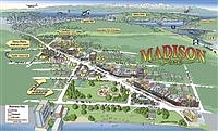
Schmieding’s Madison Park project features miniature beachgoers on the shores of Madison Park beach, a seaplane landing in distant South Lake Union, and a leaping Orca that dwarfs the Space Needle.
“We wanted him to show how close we are to downtown Seattle and the lake,” Jones said.
The release of the map is set to precede Madison Park Days, which takes place on Saturday, July 15.